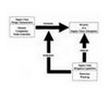
The second step to creating a road network in raster GIS is to impose constraints on the flow that can take place from cell to cell. The value assigned to the centre cell in a 3×3 window indicates the directions the flow can take in and or out of this cell. Figure 1-5 shows how a cell value of 10 is inferred from flow in direction 8 and 2.

Tomlin’s directional identifiers: Cell values indicate possible flow direction in or out of cell
The directional identifiers that are to be assigned to any given cell in a road network can be directly inferred from the Incremental Linkage values,
…


