MFworks Tutorial – 03 Incremental Linkage

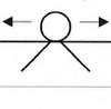
This operation infers the lineal characteristic of raster cells, by equating consecutive locations with a set of straight lines between them (Figure 1-3). Based on its relations with neighboring cells that have the same attribute value, each cell is given a linkage value indicating how it is linked to other cells.

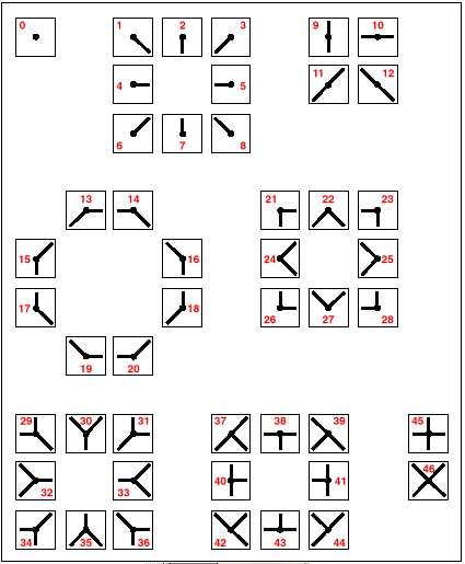
Incremental Linkage, cell value infers the linear structure it represents.
© Thinkspace

By assigning a value to each cell equivalent to the linear feature it represents it is possible to create a network similar to a road network. The smaller the cell resolution, the better the real-world road network will be approximated by this procedure.


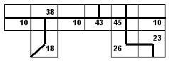
Building a road network using Incremental Linkage from
figure 1-3 with cell values representing linear features

The second step to creating a road network in raster GIS is to impose constraints on the flow that can take place from cell to cell.

MFworks – step by step

Posted in mfworks
Tags: , , ,

ARTICLES and PAPERS
A conceptual framework for supply chain vulnerability
Today's article is one of the earlier works on supply chain vulnerability, published in 2000. A conc[...]
MBA - Major Bad Ass?
Are business schools bad for business? I recently came across a very interesting article by the late[...]
BOOKS and BOOK CHAPTERS
Business Continuity in Global Supply Chains
Business Continuity is a crucial ingredient of supply chain management. At the same time, implementi[...]
Book Review: Political Risk
Egypt is in crisis. After Tunisia, now Egypt is rocked by a popular uprising, and the outcome of the[...]
REPORTS and WHITEPAPERS
Will Climate Change have an impact on transportation?
Many studies have already examined the potential impacts of climate change on broad sectors of the e[...]
Stemming the rising tide
Are you are taking radically different actions than your peers when it comes to supply chain risk ma[...]