The key to producing a successful network model is in understanding the relationship between the characteristics of physical network systems and the representation of those characteristics by the elements of the network model. The efficacy and validity of the network depends on how precisely the network can be modeled to match the real world network it represents. A network can be explicitly modeled in vector GIS, but can only be approximated by a raster GIS like MFworks.
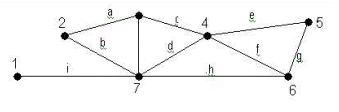
Network representation in vector GIS: Nodes (numbers) and arcs (letters)
A network in vector GIS takes the form of edges (or arcs) connecting pairs of nodes (or vertices). Nodes can be junctions and edges can be segments of a road. For a network to function as a real-world model, an edge will have to be associated with a direction and with a measure of impedance, determining the resistance or travel cost along the network.
Even if it does not appear so explicitly, a grid made up of cells in a raster GIS is in fact a graph representing a network, with 8 possible directions from each node. However, the grid cells only approximate the exact shapes of the lines in the network. Also, the direction is not as explicitly given as in the vector model. Thirdly, the line and node attributes must be stored as a separate layer for each attribute. As a result, a network using a raster model normally consists of a vast number of layers. Since the grid has a given resolution, the cells will only approximate the exact length of the network.
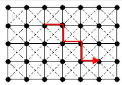
Tracing a path from cell to cell in raster GIS
generates a zigzag path instead of a straight line.
Using Tomlin’s Incremental Length, Incremental Linkage, and Directional Identifiers, which identify underlying linear features, MFworks makes it possible to model a road network in raster GIS in much the same manner as in vector GIS. The first step is to extract linear features from neighboring raster cells; the second step is to assign directions.