Blog Archives

MFworks Tutorial – 03 Incremental Linkage

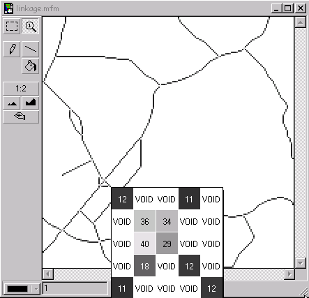
This operation infers the lineal characteristic of raster cells, by equating consecutive locations with a set of straight lines between them (Figure 1-3). Based on its relations with neighboring cells that have the same attribute value, each cell is given a linkage value indicating how it is linked to other cells.

Incremental Linkage, cell value infers the linear structure it represents.
© Thinkspace

By assigning a value to each cell equivalent to the linear feature it represents it is possible to create a network similar to a road network. The smaller the cell resolution, the better the real-world road network will be approximated by this procedure.

Read more

Posted in mfworks
Tags: , , ,

MFworks Tutorial – 04 Directional Identifier

The second step to creating a road network in raster GIS is to impose constraints on the flow that can take place from cell to cell. The value assigned to the centre cell in a 3×3 window indicates the directions the flow can take in and or out of this cell. Figure 1-5 shows how a cell value of 10 is inferred from flow in direction 8 and 2.


Tomlin’s directional identifiers: Cell values indicate possible flow direction in or out of cell

The directional identifiers that are to be assigned to any given cell in a road network can be directly inferred from the Incremental Linkage values,

Read more

Posted in mfworks
Tags: , , ,

MFworks Tutorial – 10 Deriving Linkage

linkage = IncrementalLinkage network;

The Linkage operation assigns values indicating how cells are linked together.

MFworks – step by step

Read more

Posted in mfworks
Tags: , ,

ARTICLES and PAPERS
Friend or foe or both?
Realities of supply chain collaboration
Supply chain collaboration, easy or difficult? And can it really work? In theory yes, but in reality[...]
Acts of God or Acts of Man?
Do we ever learn? How come we humans knowingly and willingly put ourselves and our critical infrastr[...]
BOOKS and BOOK CHAPTERS
Book Review: This is where raster GIS started...
...well not really, but Geographic Information Systems and Cartographic Modeling by Dana Tomlin spar[...]
Risk and vulnerability in maritime supply chains
This week's focus are risks in the maritime supply chain. Today's article reflects on security in ma[...]
REPORTS and WHITEPAPERS
A Decade of Living Dangerously
Do you remember the movie The Year of Living Dangerously with Mel Gibson? Topically unrelated maybe,[...]
The UK Transport Network Resilience...and I
UK Transport Network Resilience
For a budding and even for a seasoned researcher, nothing is more rewarding than to have one's publi[...]
from HERE and THERE
Somali pirates forcing ships to make detour
In an earlier article today I quoted several sources saying that shipping companies are now seriousl[...]
JavalancheTM – analyzing hazards to roads
Traditionally, in studying the effect of hazards on roads, a hazard map is prepared based on the haz[...]