Yearly Archives: 2002

ArcView Network Analyst Tutorial

This tutorial was developed by Jan Husdal at the University of Utah, Salt Lake City, 2000-2002. It shows how to solve 3 categories of network analysis problems; Find Best Route, Find Closest Facility and Find Service Area, and it comes complete with exercise data and solutions.

Posted in THIS and THAT
Tags: , , ,

Pålitelighet og sårbarhet av transportsystemer

Transportsystemer som veg og jernbane danner ryggraden i et moderne samfunn. Påliteligheten og sårbarheten i et transportsystem blir dermed avgjørende faktorer ikke bare i konkurranse- og markedsøyemed, men også i beredskapssammenheng, for å kunne opprettholde normal samfunnsdrift.

Posted in THIS and THAT
Tags: , , , , , ,

The reliability and vulnerability of transportation lifelines

Transportation networks like freeways and interstate highways are the main backbone of modern society. Consequently, the reliability or vulnerability of any transportation network is thus a decisive factor not only in terms of market outreach and competition, but also in terms of continuity, to ensure a 24/7 operation of the community we live in.

Posted in THIS and THAT
Tags: , , , , ,

JavalancheTM – analyzing hazards to roads

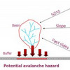
Traditionally, in studying the effect of hazards on roads, a hazard map is prepared based on the hazard in question, the contributing factors and then overlaid with a road map. If the road or a buffer around its vicinity intersects hazard areas, these areas constitute a potential threat. In the approach used in this procedure, imagine traveling along the road and looking to either side for hazards.

Posted in THIS and THAT
Tags: , , ,

Shortest Path Computation: A Comparative Analysis

Current research work into establishing a performance efficiency hierarchy between Java, C++ and ArcView is described and experimentation is performed in order to statistically compare shortest path query execution time, response time and implementation issues.

Posted in my PUBLIC PRESENCE
Tags: , , , , , , , ,

A spatial framework for modeling hazards to transportation lifelines

Transportation networks are exposed to a wide range of natural hazards and this study has developed a GIS tool for analyzing these hazards. The primary hazards included in this study are avalanches, landslides, flooding, earthquakes, wildfires, and rockfall. The GIS software used was MFWorks

Posted in my PUBLIC PRESENCE
Tags: , , ,

Book review: Networks and Algorithms

This book tells you the difference between the various types of graphs, trees and networks and shows you step by step calculations on how to solve them by hand (they didn’t have that many computers in 1993).

Posted in BOOKS and BOOK CHAPTERS
Tags: ,

ARTICLES and PAPERS
A Future Research Agenda for Supply Chain Risk
When Manuj and Mentzer (2008) wrote their article titled Global Supply Chain Risk Management, they [...]
Emergency Logistics
Can commercial logistics' ideas and solutions work in humanitarian supply chains? No. Why? Well, per[...]
BOOKS and BOOK CHAPTERS
Risk and resilience in maritime logistics
This week's focus are risks in the maritime supply chain and today's paper sets out a framework for [...]
Risk Management in Maritime Transportation Networks
This week’s focus are risks in the maritime supply chain, and today's article introduces a new metho[...]
REPORTS and WHITEPAPERS
Managing supply chain risk
In September and October 2009 the Economist Intelligence Unit surveyed 500 company executives with r[...]
Calculating the Value-at-Risk
Some of you may remember that I posted about the SCOR Framework for Supply Chain Risk Management ear[...]
from HERE and THERE
Norwegian roads are slooooow...
In a previous post, a while I ago, I stated that Nowegian roads are dangerous...well, not only that,[...]
Cost-Benefit Analysis – an essay about valuation problems
This paper introduces vulnerability as an important parameter for decision-support in cost-benefit a[...]